One Table, One Day, One Rule
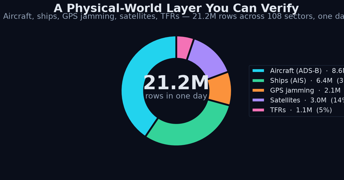
Everything in this post was measured on 2026-08-24 and lands in a single ClickHouse table (market_ticks): 21.2 million rows across 108 sectors in the last 24 hours, each row carrying its source. The rule is provenance-or-silence — if we can't tell you where a number came from and how to check it yourself, we don't publish it.
Here's what the physical-world layer looked like today.
437 Military Aircraft Airborne, Right Now
As of 2026-08-24T14:07Z, our ADS-B collector counted 437 military aircraft airborne worldwide: 218 over North America, 101 over Europe, 11 over South America, 3 over the Middle East, 2 over Asia, 1 over Africa.
Caveat, stated plainly: this is transponder-visible military aviation only. Aircraft flying dark, or over regions with thin receiver coverage, don't appear. The regional split reflects receiver density as much as actual activity — North America and Europe have dense volunteer ADS-B receiver networks; Africa and Asia do not. Treat the series as a floor and watch the deltas, not the absolute level: a region jumping from its own baseline is signal even when the baseline undercounts.122 Active FAA Flight Restrictions
At 14:15Z there were 122 Temporary Flight Restrictions active in US airspace: 54 hazard, 48 security, 6 space-operations, 3 VIP. TFRs are a leading indicator with a paper trail — a space-operations TFR appears before the launch it protects, a VIP TFR before the movement it screens. We poll the FAA's own list, so the denominator is exactly what the FAA publishes: US airspace only, no inference.
926 Map Cells at HIGH GPS Interference
For 2026-08-22 — the latest complete day; the upstream source lags about two days — 926 map cells worldwide showed HIGH GPS interference: 394 in Europe, 210 in the Middle East, 108 in Asia. 508 aircraft reported degraded GPS that day. We hold 29 days of history since 2026-07-25.
Method matters here: this data is derived from aircraft self-reporting their navigation accuracy over ADS-B. A "HIGH" cell means a large share of aircraft crossing it reported degraded GPS. Same receiver-density bias as above — a jammed cell with no ADS-B coverage is invisible — and a cell needs traffic to be measured at all. What the series is genuinely good for: tracking the expansion and contraction of known interference zones day over day, which is exactly what 29 days of aligned history lets you do.
Kuiper at 391, Qianfan at 238
From public TLE catalogs, as of 2026-08-24T14:02Z: Starlink at 10,969 tracked objects, Kuiper at 391, Qianfan at 238, and 203 objects launched in the last 30 days, across 26 constellation series we snapshot daily. Constellation build-out is one of the few competitive races you can watch in a public catalog: every tracked object has a NORAD ID, and the count either grows or it doesn't. "Tracked objects" is the honest unit — it includes spacecraft not yet in service and excludes nothing that's in the catalog.
4,148 Ships on National AIS Feeds
At 14:15Z we tracked 4,148 vessels live from two national AIS feeds: Norway 3,491 (2,330 underway) and Finland 657 (342 underway, 291 port calls in the last 24 hours). These are government-operated coastal AIS networks — Kystverket and Fintraffic — not a commercial aggregator, so the coverage boundary is explicit: these two countries' waters, terrestrial AIS range. Within that boundary you get vessel-level positions, navigational status, and port-call events with no licensing ambiguity about redistribution of derived statistics.
Why One Table
The point isn't any single feed — dashboards exist for each of these. The point is that military flight activity, airspace restrictions, GPS interference, constellation deployment, and shipping all land in the same table with the same schema, timestamped and source-tagged, next to supply telemetry from 372 DePIN networks (3,891 first-party series as of 2026-08-26). Cross-domain questions — did jamming cells expand where military sorties rose? did port calls dip during a coastal restriction? — become one SQL join instead of five scraping projects. And because every row carries its source, every answer is auditable back to the instrument that produced it.
Verify It Yourself
Don't trust our numbers — check them against the same upstreams we poll:
- Military aircraft:
curl https://api.adsb.lol/v2/mil— count the aircraft in the response yourself. - TFRs: tfr.faa.gov — the FAA's live list, filterable by type.
- GPS interference: gpsjam.org — pick 2026-08-22 in the date selector and count HIGH cells by region.
- Satellite TLEs: celestrak.org/NORAD/elements/ — pull the Starlink, Kuiper, or Qianfan group files and count lines.
- AIS:
curl https://meri.digitraffic.fi/api/ais/v1/locationsfor Finland; Norway's feed is via kystverket.no.
Getting the Data
The same provenance-first API that serves our DePIN telemetry for hundreds of networks fronts this layer. Endpoints and schemas are in the API docs, and you can try it without a card. If you're comparing how we normalize wildly different physical feeds into one schema, our post on cross-category supply telemetry covers the approach.
Data access starts free; the $199 Design Partner tier gets you the full firehose and a direct line to us — pricing here.
---
Try it yourself
Query the live catalog, supply telemetry, and provenance receipts directly: /v1/networks, /v1/supply on the REST API.
Related reading: DePIN Intelligence guide · DePIN network data: 372 networks, 138 sources · how we read supply telemetry from 296 networks · the DePIN developer guide
Design-partner seats are capped at 20 at a lifetime-locked $199/mo (full API access, every published endpoint, MCP server, Bitcoin-anchored provenance). After seat 20 the price becomes $249/mo. Claim a design-partner seat → · See pricing---
Get Started With DePIN Intelligence
Kairos Signal provides verifiable, provenance-first telemetry for DePIN networks, including first-party supply data read directly from a network's own API or blockchain. Every value carries a verify_url you can check yourself, and each daily batch is Merkle-rooted and anchored to Bitcoin.
Every API response is signed with ed25519 and timestamped. You can prove what was served and when, months later. That is what we mean by provenance-first.
Related reading: DePIN Intelligence Guide · DePIN Telemetry · How to Query DePIN Data · DePIN Data Verification · Pricing